Rupununi: Balancing Development with Conservation
A launch post for rupununi.org and the blog series on conservation and sustainable development in Guyana’s Rupununi.
Guyana’s Rupununi is no longer ‘out of the public eye.’ New national priorities are emerging. New markets are developing. New infrastructure is shifting the interior from the periphery of national planning to the center of national ambition. The most visible symbol is the road corridor linking the coast to Lethem on the Brazilian border. Major upgrades are intended to convert long stretches of dirt road into an all‑weather route. These upgrades will remove bottlenecks, like the Kurupukari crossing.
This connectivity can bring real benefits: lower transport costs, better access to services, and new opportunities for trade and tourism. But it also changes the risk profile for the Rupununi’s wetlands, savannas, forests, and communities. Environmental and planning assessments of the road corridor have documented risks. Roads and the development they attract can fragment habitats. They can also alter water flows across wetlands and savannas in ways that are hard to reverse.
This launch post is written for a mixed audience. It includes Guyanese readers, international conservation partners, and policymakers in Guyana and Brazil. Decisions about roads, land use, and conservation now have cross‑border consequences. The Rupununi sits at the interface of two great South American basins: the Amazon and the Essequibo.
The central challenge, well understood from development experience across the wider region, is getting the sequence right. Infrastructure should not arrive first. Otherwise, land conversion follows, and conservation becomes an afterthought. In the Rupununi, that sequence would be especially costly. This is due to the region’s ecology being organized around seasonal flooding. It also involves basin-to-basin connectivity.
Guyana’s development strategy aims for a specific outcome. The goal is to improve lives while maintaining the Rupununi’s ecological functions. This includes the seasonal flood dynamics and the Amazon–Essequibo ‘portal.’ It also encompasses the cultural landscapes stewarded by Makushi and Wapishana communities.
The opportunity: the Rupununi is already established as part of the world’s biodiversity and climate solution set. LCDS 2030 is one of the most ambitious low-carbon development commitments in the world. It is designed to integrate economic growth with environmental preservation. It also aims to scale investments in communities and conservation. The Rupununi is a place where the promise of that framework becomes real. This depends on designing infrastructure and land use around water, wildlife, and community governance.
Why the Rupununi Stands Apart
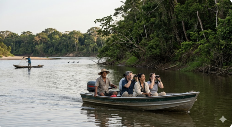
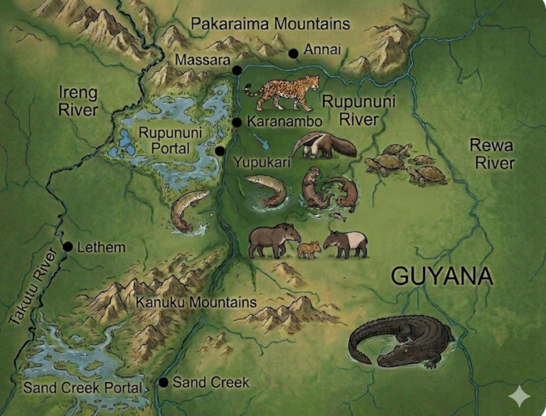
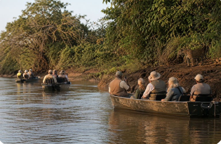
Habitat diversity drives exceptional vertebrate richness. The Rupununi is a mosaic of savannas, wetlands, river corridors, and forests—including the Kanuku Mountains and the Iwokrama forest landscape. This habitat diversity is one reason the region is considered to support exceptionally high vertebrate richness. The richness is often summarized as ‘more than 1,400 vertebrate species.
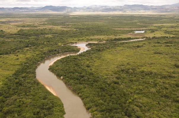
The Rupununi Portal links two major South American drainages. During the rainy season, water can flow into the Amazon Basin through the Takutu. They can also connect to the Essequibo Basin through the Rupununi. Scientists call this hydrological corridor the ‘Rupununi Portal’. Research on fish distribution emphasizes the interdependence of the corridor’s different habitat types. This interdependence is crucial for maintaining biodiversity.
Makushi and Wapishana history is not ‘background’—it is an operating system. The Rupununi is a cultural landscape with deep time depth. There is archaeological evidence of a long human presence. It highlights Indigenous technologies for cassava cultivation and processing. The summary also covers the central place of Makushi communities in the North Rupununi before European contact. The region is also home to Wapishana communities, whose livelihoods and knowledge systems are tied to the same flood‑driven ecology.
Water First: How the Flood Pulse Runs Everything
The Rupununi is organized around water moving across a flat landscape. In flood season, waters expand into a vast inland wetland complex, creating hundreds of lakes, ponds, and seasonally flooded depressions. That flood pulse is not just ‘scenery.’ It is the mechanism that connects habitats, moves nutrients, and makes the region productive for both people and wildlife.
Fauna responds through longitudinal and lateral migration. Fish and other aquatic species respond to the flood pulse. They move along river channels for longitudinal movement. They also move out onto flooded savannas and wetlands for lateral movement. Research on the Rupununi Portal indicates that fish assemblages are structured by water body type, vegetation, and water chemistry. The mosaic of habitats in the portal maintains high biodiversity. Conservation organizations similarly emphasize that seasonal flooding allows aquatic wildlife from different basins to mix, supporting exceptional freshwater diversity.
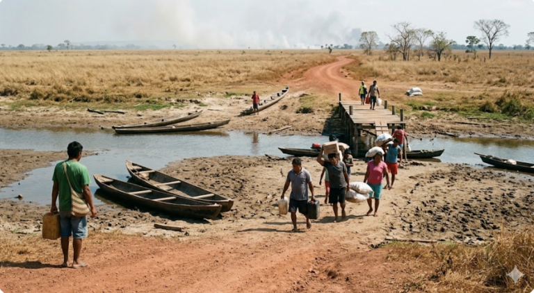
Flood cycles structure livelihoods—fishing, farming, and resource use. When floodwaters spread, fish disperse to feed and spawn on floodplains. As the waters recede, fish concentrate again. This creates predictable seasonal opportunities for fishing and food security. Many note that Indigenous communities rely heavily on fish as a main protein source. They also depend on other nature‑based wetland resources. The same seasonal pattern shapes when and where people farm, travel, and harvest materials.
Development risks: how roads and land conversion can disrupt flooding (and be disrupted by it). Road upgrades and new crossings are designed to keep the corridor open longer and reduce travel times. Yet, the corridor crosses sensitive wetlands and Indigenous communities. Environmental and engineering assessments have identified risks. Roads can compromise hydrological connectivity. This is especially true where water needs to move laterally across the landscape during high water. The risk mechanism is straightforward. A road embankment that blocks or reroutes seasonal sheet flow can cause some areas to dry out. It can waterlog others. That impacts fish movements and wetland productivity. It also affects the reliability of local water sources. It can undermine the road itself due to flooding. Maintenance burdens can also result. The appropriate response is not one of ‘no roads.’ An appropriate response involves planning and design. These focus on water movement as a primary constraint. Bridges, culverts, and alignments are used to preserve seasonal connectivity and protect key migration corridors.
Making LCDS 2030 Work in the Rupununi
Guyana’s LCDS 2030 is clear about the national strategy. It emphasizes valuing ecosystem services and investing revenues in low-carbon priorities. The strategy also ensures that Amerindian and hinterland communities gain through dedicated mechanisms. These mechanisms include a guaranteed share of carbon-credit revenues that communities can self-manage through Village Sustainability Plans. That strategy—and Guyana’s track record in advancing it—creates an opportunity to show what ‘doing development differently’ means in practice. This approach is particularly relevant in the Rupununi. Local institutions and ecological realities are used as the starting point.
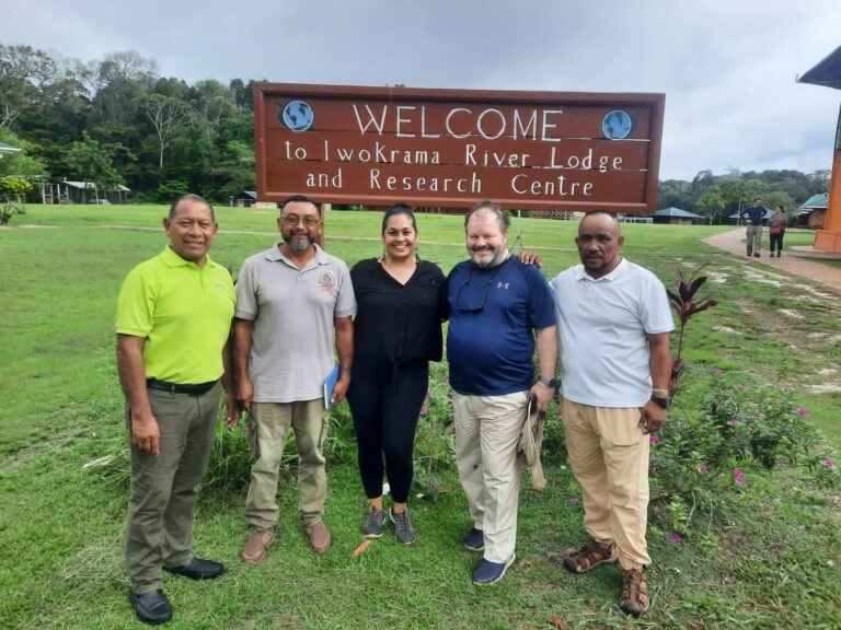
Indigenous stewardship and cultural heritage are core infrastructure. The most durable conservation capacity in the Rupununi is local. The North Rupununi District Development Board (NRDDB) was established as a community‑based organization. It stands for North Rupununi villages and coordinates educational, cultural, research, and development programs. Iwokrama describes the NRDDB as a major success in community‑based management capacity and partnership. That matters because local rules and institutions shape whether biodiversity persists outside formal reserves.
Local organizations already operate at the conservation–livelihood frontier. A concrete example is fisheries co‑management. Case studies describe declines in arapaima populations driven by illegal fishing. The NRDDB and communities developed an Arapaima Management Plan. This plan is based on community monitoring, enforcement, and locally legitimate sanctions. This is the pattern that works in floodplain systems: rules matched to ecology, enforced by people with long‑term stakes.
‘Alignment’ means development that fits biodiversity and culture, not the other way around. LCDS 2030 outlines a national commitment. It aims to integrate economic growth with environmental preservation. Additionally, it seeks to expand biodiversity protection and to focus on water management. In practice, that commitment translates to three questions. Guyana’s own planning frameworks are well placed to answer these for any major development in the Rupununi. First, does it preserve flood connectivity and water quality? Second, does it strengthen community governance rather than bypass it? Third, does it limit land‑use change to levels that allow large predators to survive? Does it allow migratory fish and wetland food webs to work?
Three Messages, Three Actions
This first post has one purpose: to make the Rupununi legible as a system now, as decisions accelerate. The key messages are three:
1) The Rupununi’s global value is real and measurable—high vertebrate richness linked to habitat diversity, and a rare hydrological corridor between major basins.
2) The flood pulse is the operating mechanism —it sustains wildlife and livelihoods, and it is easy to disrupt unintentionally with poorly designed infrastructure and land conversion.
3) Sustainable development is possible because local institutions already exist—NRDDB and allied community organizations have decades of experience coordinating conservation and development, and have demonstrated working models such as co‑managed fisheries.
Call to action for local and national actors:
– Treat the Rupununi Portal and key wetland corridors as ‘no‑regret’ ecological infrastructure. Design roads and crossings to preserve water movement and fish migration. Review the outcomes transparently.
– Scale community‑led planning. Include enforcement (Village Sustainability Plans, local conservation rules) as part of LCDS implementation. Do not treat it as a side program.
– Expand conservation corridors and Indigenous Community Conservation Areas. They strengthen intact habitats and protect the floodplain role. Current conservation initiatives in the Rupununi explicitly target large areas through ICCAs.
If Guyana does this well, the Rupununi can become a landmark example. The institutions already in place suggest it can. It shows what the world says it wants: biodiversity protection that improves livelihoods. This is backed by credible finance and implemented by communities with deep knowledge of the land. LCDS 2030 is Guyana’s own blueprint for that outcome. The future of the Rupununi—and the global standing of Guyana’s low‑carbon development model—will be defined by the choices made now.
Why I wrote the book. I wrote *Rupununi: Rediscovering a Lost World*—‘lost’ in the sense of being overlooked by the wider world. This was not the case for the Makushi and Wapishana communities, who have been its stewards for generations. I wanted to highlight a place that deserves recognition for its ecological and cultural significance. It should be recognized on the same scale as iconic conservation landscapes worldwide. The Rupununi has captured the imagination of explorers and naturalists for centuries. Yet, for long periods, it received far less sustained attention than it deserves. The book (first published in 2010) was meant to introduce the Rupununi to a wider international audience. It aimed to make the case—using plain evidence— that its biodiversity and people matter.
Why update now? The case for attention has not diminished; the decision context has changed. Since 2010, Guyana has advanced a national Low Carbon Development Strategy (LCDS 2030). It frames development around the value of ecosystem services. The strategy aligns with global climate and biodiversity goals. It also invests in Amerindian and hinterland development through dedicated mechanisms. At the same time, Guyana is investing significantly in the road corridor. This is a strategic national priority. The pace of change in the interior is accelerating. This website and blog series exist to update the facts. They connect these facts to current choices. They keep the Rupununi legible as a living system—not empty space.
Discover more from Rupununi: Rediscovering a Lost World
Subscribe to get the latest posts sent to your email.