Meeting the Flood Pulse: The Development Choices Facing Guyana’s Rupununi
An oil boom meets a flood-pulse ecosystem
Guyana’s 2015 offshore oil discovery has unleashed an extraordinary commodity boom, making roads, large-scale agriculture, and mining realities for the Rupununi. As in all past LAC commodity booms, national decision-makers face a core challenge: how to capture the windfall to ensure durable benefits.
But the Rupununi is not empty land. Its biodiversity, Indigenous livelihoods, and resilience to climate extremes are driven by a seasonal flood pulse that researchers are only beginning to map. Misaligned development risks treating an active, dynamic floodplain as static ground — and the LCDS 2030 has already positioned the Rupununi as the test case for doing this as well as possible.
ENSO events are becoming more intense and more frequent due to climate change. These shifts in the Intertropical Convergence Zone (ITCZ) amplify drought and flood cycles in the Rupununi. Severe floods hit the South Rupununi in 2011. Recurrent floods in 2012, 2013, and 2014 disrupted agriculture there. Floods damaged the Georgetown–Lethem Road in 2017. In 2018, floods destroyed farms, bridges, and road infrastructure. The government declared a national flood disaster on 9 June 2021—the worst in over 20 years. An El Niño drought in 2015–2016, conversely, suppressed flooding entirely, causing losses in fisheries, water supply, and livestock.
This blog examines this complex hydrological system in more detail. It evaluates the connections between hydrology, biodiversity, and livelihoods. It then assesses the management challenges faced by agriculture, mining, and infrastructure in the Rupununi.
How water moves through the Rupununi
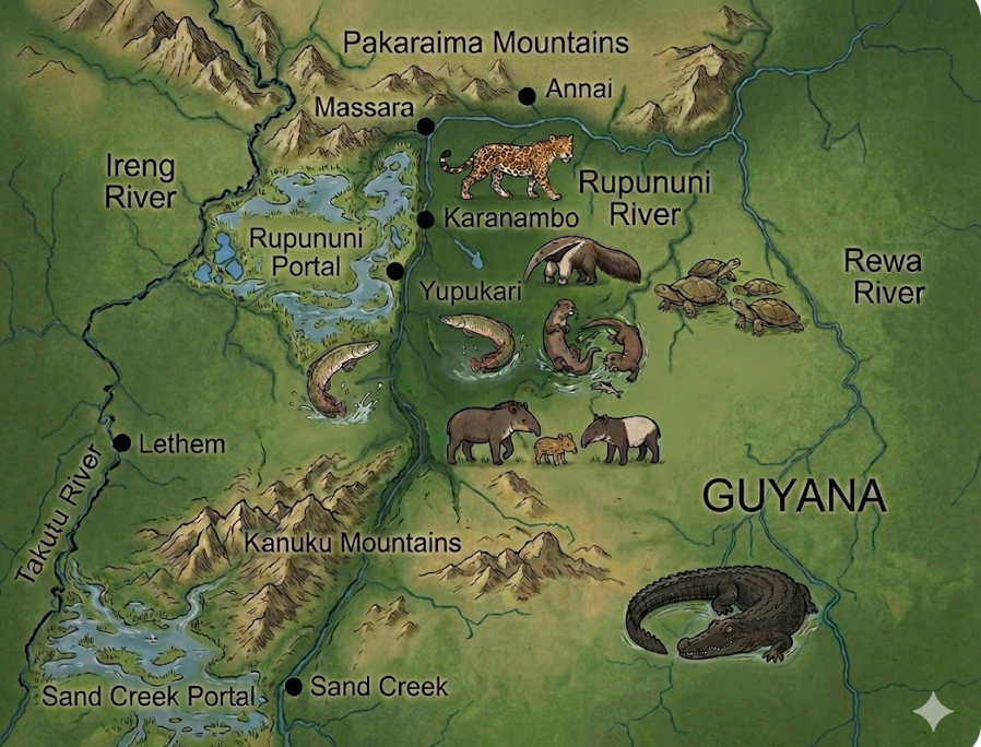
The Rupununi, Takutu, Ireng, Rewa, and Essequibo Rivers sit in the Takutu graben basin. This flat mid‑Mesozoic rift valley lies between the Pakaraima and Kanuku Mountains. Its microtopography traps water from rainfall and from backwater. Better monitoring has improved our picture of this complexity. Information still falls short of a full account of the area’s hydrology.
The ITCZ drives the flood cycle. The wet season runs from May to September; the dry season, from October to April. During the dry season, evapotranspiration and low soil moisture levels cause wetlands to shrink rapidly. Shallow lakes and creeks often dry up entirely. In the wet season, the flat, low‑lying savannas transform into a flooded plain of several thousand square kilometers.
A broad mechanism sustains long‑term flooding. The larger Essequibo River, at its juncture with the Rupununi, limits downstream flow. It pushes water back upstream, causing backwater flooding. The Amazon does the same along the Trombetas, Madeira, Negro, and Purus Rivers. Backwater flooding from the Rupununi interacts with overtopping from the Ireng River in the north and the Takutu River in the south. When these rivers flood together, the Takutu Graben fills extensively. The Rupununi River has two portals — seasonal hydrological bridges between watersheds. These portals connect the Essequibo drainage to the Rio Branco and the Amazon via the Ireng and Takutu Rivers.
Climate change alters these dynamics by shifting ENSO intensity and frequency. During El Niño events, the Rupununi experiences severe droughts. During La Niña events, prolonged flooding exceeds normal levels. These extremes disrupt traditional Indigenous farming and subsistence fishing. They also deepen existing food‑security challenges.
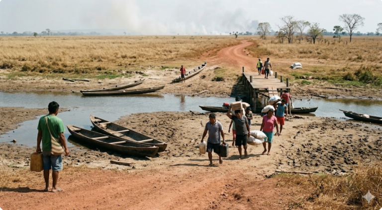
Floods disrupt local communities by destroying infrastructure. The floods wash away roads, bridges, and drainage systems, and cut the area off from the outside. Droughts, by contrast, deplete shallow lakes and groundwater wells. They cause high fish mortality and reduce the water available for agriculture. Combined with high temperatures, droughts also increase vulnerability to uncontrolled forest and savanna fires, which have grown increasingly damaging.
What the flood pulse sustains: fisheries, biodiversity, and Indigenous economies
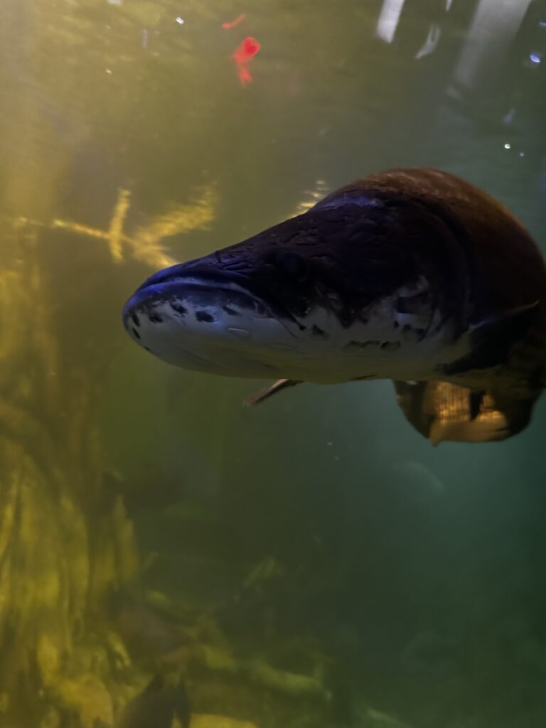
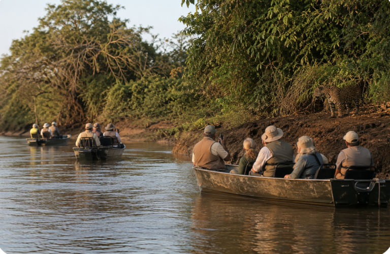
The Rupununi is one of the most biodiverse regions in the world. Researchers have recorded about 70% of Guyana’s vertebrate species there. The wetlands and forests shelter globally endangered species, including jaguars, giant river otters, harpy eagles, giant anteaters, black caiman, and Arapaima. High habitat heterogeneity underpins this diversity — the landscape ranges across tropical savannas, bush islands, gallery forests, and seasonally flooded forest and savanna wetlands.
The seasonal flood pulse is a crucial element of the region’s ecology. Rising waters trigger fish migration — longitudinally upriver and laterally into flooded wetlands, where fish feed and spawn. The Rupununi and Sand Creek portals act as zoogeographical filters. They let hypoxia‑tolerant species like Arapaima cross watersheds but block strictly riverine species. As waters recede, many fish remain trapped in shrinking, hot savanna ponds — crowded and low in oxygen — that then feed abundant birds.
The seasonal rise and fall of water levels shape the livelihoods of Makushi and Wapishana. The rains provide water for farming and reshape gathering and hunting practices. Makushi and Wapishana communities are experts at tracking migratory fish populations. Freshwater fish supply up to 60% of the dietary protein for Rupununi communities.
Wildlife and fisheries increasingly anchor community‑based ecotourism, a growing and already vital source of revenue. Other commercial activities generate local income but harm wildlife populations. Traders capture birds for the pet trade and harvest turtles and larger fish for commerce. In the past, hunters overhunted black caiman and giant river otters.
Three development pressures, one hydrology: roads, agriculture, and mining
The Georgetown–Lethem Road connects the Rupununi to the rest of Guyana and Guyana to Brazil. The road can cut transport costs for people, goods, and raw materials. It brings improved access to health, education, and other basic services. All‑season, well‑maintained roads deliver the largest benefits. Affordable transport services and strong local and regional institutions amplify those gains.
However, the road bisects the watershed and floodplain. Without proper engineering, it can disrupt water flow across the savanna and over the portals, fragmenting connectivity. A poorly designed road will also not survive severe seasonal flooding, as the region has repeatedly shown.
The road can also improve the feasibility of large‑scale agriculture. But these savanna soils are nutrient‑poor. Flooding replenishes nitrogen, phosphorus, potassium, and organic carbon. Commercial agriculture based on heavy fertilizer and pesticide inputs could damage this sensitive freshwater ecosystem.
Water flows play a central role in the Rupununi. Large‑scale agriculture and its water demands can directly threaten the hydrological balance and fish spawning grounds. Similar impacts are already evident in the Florida Everglades, the Cauca River Valley, the Orinoco Llanos, and the Pantanal. In these places, sugarcane, soy, cattle, and fruit production have reduced and simplified wetlands.
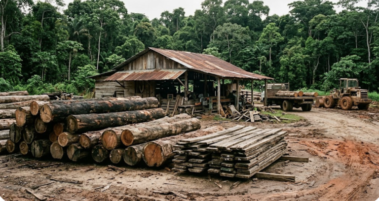
Mining also threatens the wetlands. Gold mining around Marudi Mountain in the South Rupununi has caused sedimentation, increased turbidity, and deforestation. Mining close to or within river and creek beds disrupts water flow. It can degrade spawning areas and turn seasonal creek beds — once crucial for migration and spawning — into useless habitats.
The LAC pattern is clear. Mining in riverbeds, mercury use, and community dependence on fish‑based diets have produced disasters. Madre de Dios, Tapajós, Madeira, and Xingu illustrate the combined effects.
Implications for planners: the Rupununi as an LCDS 2030 test case
The Rupununi is a seasonally connected flooded system linking the Essequibo and Amazon basins. The connecting hydrological mechanisms are complex, and researchers are only now beginning to understand them better. Indigenous livelihoods and biodiversity depend on the annual flood pulse, which ENSO events strongly shape. Road construction, large‑scale agricultural expansion, and gold mining each pose risks that governments must manage carefully.
The key task is to deepen understanding of the complex hydrology of the Rupununi and the linked Takutu and Ireng River basins. This information can support government planning for infrastructure and agriculture. It can also strengthen monitoring of mining impacts.
The LCDS 2030 formally positions the Rupununi as a test case for development designed around complex, climatically sensitive hydrological systems. Development in the Rupununi must maintain natural flood pulses, groundwater recharge, and wet–dry season connectivity. Disrupting these dynamics would undermine biodiversity, Indigenous livelihoods, and Guyana’s broader low‑carbon and adaptation objectives.
Discover more from Rupununi: Rediscovering a Lost World
Subscribe to get the latest posts sent to your email.